Revealed – extent of damage from Jasper wildfire

Revealed – extent of damage from Jasper wildfire | Insurance Business Canada
Catastrophe & Flood
Revealed – extent of damage from Jasper wildfire
Federal government gives an update
Catastrophe & Flood
By
Terry Gangcuangco
The government has outlined the extent of damage from the Jasper wildfire, which is now known as the Jasper Wildfire Complex.
In a 9pm wildfire status update on Sunday (July 28), Jasper National Park stated: “Another day of reduced fire behaviour allowed our 350 firefighters and personnel to make progress again today.
“Today firefighters from Parks Canada and Alberta Wildfire were again busy mopping up wildfires near values at risk. They were joined by Ontario firefighters who attacked the north line on the Palisades bluffs and the Canadian Armed Forces working on mopping up spot fires near the northwest side of town.”
It was announced that a broader control line on Whistlers Mountain was also created by widening the Jasper Skytram Road with bulldozers. The move is aimed at protecting the community of Jasper from the increased fire activity expected on August 1.
“Weather forecasts indicate that dry conditions will make it easier for the wildfire to grow, making the progress now so important,” the update continued.
“The 12” high volume sprinkler line along the community fire guard is nearing completion which will provide the contingency control feature for the community from fire spread from the west or north.”
‘A third of town destroyed’
At 10pm on July 26, Jasper National Park said damage within the townsite was estimated at around 30%.
“Out of a total of 1,113 structures within the town, 358 have been destroyed,” it was noted on Friday. “However, all critical infrastructure in Jasper were successfully protected including the hospital, the library, and the firehall.
“We are grateful to our responders’ efforts to contain the fire, minimize the damage, and begin to restore essential utilities.
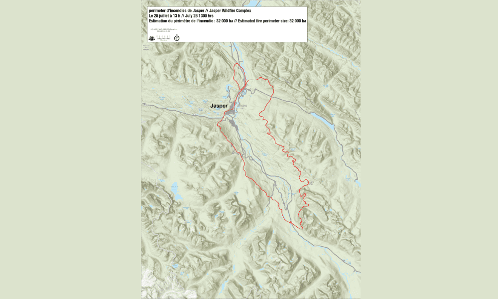
Meanwhile, an updated fire perimeter map (seen above, courtesy of Jasper National Park) has been released.
“An initial aerial survey of the perimeter was conducted July 26, 2024 and determined the fire size to be approximately 32,000 hectares, with no significant changes over the last two days,” the government reported on Sunday.
“The outline shown in the map represents an estimate of the furthest area burned, not what is currently burning. It is important to note that this is an estimate and will change when there is a chance to do more detailed mapping.
“Within the estimated perimeter there will be areas completely burned, partially burned, and areas which did not burn at all.”
What do you think about this story? Share your thoughts in the comments below.
Related Stories
Keep up with the latest news and events
Join our mailing list, it’s free!


