Idalia forecast to be “extremely dangerous major hurricane” for Florida

Idalia has now become a hurricane, running a little behind the forecast schedule as it meandered around Cuba, but now moving into the far southern Gulf of Mexico, the NHC warns hurricane Idalia will be an “extremely dangerous major hurricane” for Florida.
Hurricane Idalia is set to rapidly intensify right the way up to landfall, according to the NHC.
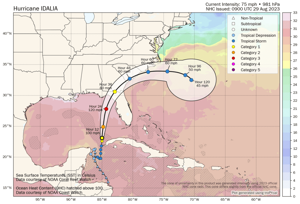
In fact, the latest forecast advisory now sees a major hurricane Idalia with sustained winds of 120 mph reaching the Gulf Coast of Florida, while gusts are expected to be approaching 150 mph as landfall nears.
The hurricane Idalia intensity forecasts from the NHC have eventually converged with what the main hurricane forecast models had been saying a few days ago, that the storm is likely to be Category 3 at least when it approaches the Panhandle region of the Florida Gulf Coast.
That’s a really significant storm, with the potential for significant property damage and loss of lives, as well as commensurate impacts to insurance, reinsurance and perhaps catastrophe bond or insurance-linked securities (ILS) interests.
You can see the latest location for Idalia below, using Tomer Burg’s excellent map which shows wind speed forecasts in increments and sea surface temperatures as well, using the NHC data:
As we’ve said in all our updates on hurricane Idalia, the landfall location and where on the Florida coast experiences the strongest winds and highest storm surge, will be critical to defining the insurance and reinsurance market loss.
We’ve seen some early modelled loss projections, based on stochastic catalogue and analogue storms, which suggest anything in a range from $5 billion to as much as $25 billion, so far, depending on the exact landfall location. Some of those would require a pretty significant track-shift to take Idalia to a higher value coastal region, so we believe the market is largely working off a sub-$20bn estimate at this time.
But there are storms in modellers catalogues that have higher industry losses than that as well, we’re told.
However, at this stage there remains some uncertainty over just how high any industry loss could be, given the landfall location which is critical, as well as whether hurricane Idalia intensifies right up to landfall, or if land interaction can slow the storm at all as it nears the Florida coast.
Another determinant, in how large an insurance and reinsurance market loss hurricane Idalia could cause, comes down to inland impacts and the track across Florida, into Georgia and South or North Carolina.
Right now, the latest forecast data from the NHC shows hurricane Idalia still with 80 mph sustained winds as it enters the state of Georgia, so the inland impacts could be quite severe with this storm.
South Carolina is set for strong tropical storm effects, while North Carolina could still experience strong tropical storm winds along its coastline as hurricane Idalia curves out into the Atlantic.
It’s still a bit too early for any projections of loss to the reinsurance, ILS and catastrophe bond market specifically.
With the changes to attachments and terms, the primary insurers are expected to retain the lions share of any catastrophe industry loss event that falls in single figures, with the reinsurance, ILS and catastrophe bond market likely to see more significant effects as an industry loss rises into double-digits and beyond.
But, remember, at just below $50 billion still, last year’s hurricane Ian has not caused particularly significant cat bond and ILS market losses, with much of the mark-to-market decline recovered.
So, given where hurricane Idalia is tracking towards and the fact that right now that would be anticipated to result in a smaller insurance industry loss than Ian, it seems possible that even with a major hurricane landfall, the ILS market impact would be manageable and the cat bond market may not suffer too much in direct losses.
All of which is caveat with the potential for hurricane Idalia to strengthen more than expected, or hit somewhere more built-up and with a higher concentration of insured values, as that could change everything.
The latest hurricane Idalia NHC update states, “On the forecast track, the center of Idalia is forecast to move over the eastern Gulf of Mexico today, reach the Gulf coast of Florida within the Hurricane Warning area on Wednesday, and move close to the Carolina coastline on Thursday.
“Maximum sustained winds have increased to near 75 mph (120 km/h) with higher gusts. Rapid intensification is likely through landfall, and Idalia is forecast to become an extremely dangerous major hurricane before landfall on Wednesday.”
 They say that hurricane Idalia is expected to be an “extremely dangerous major hurricane before landfall on Wednesday.”
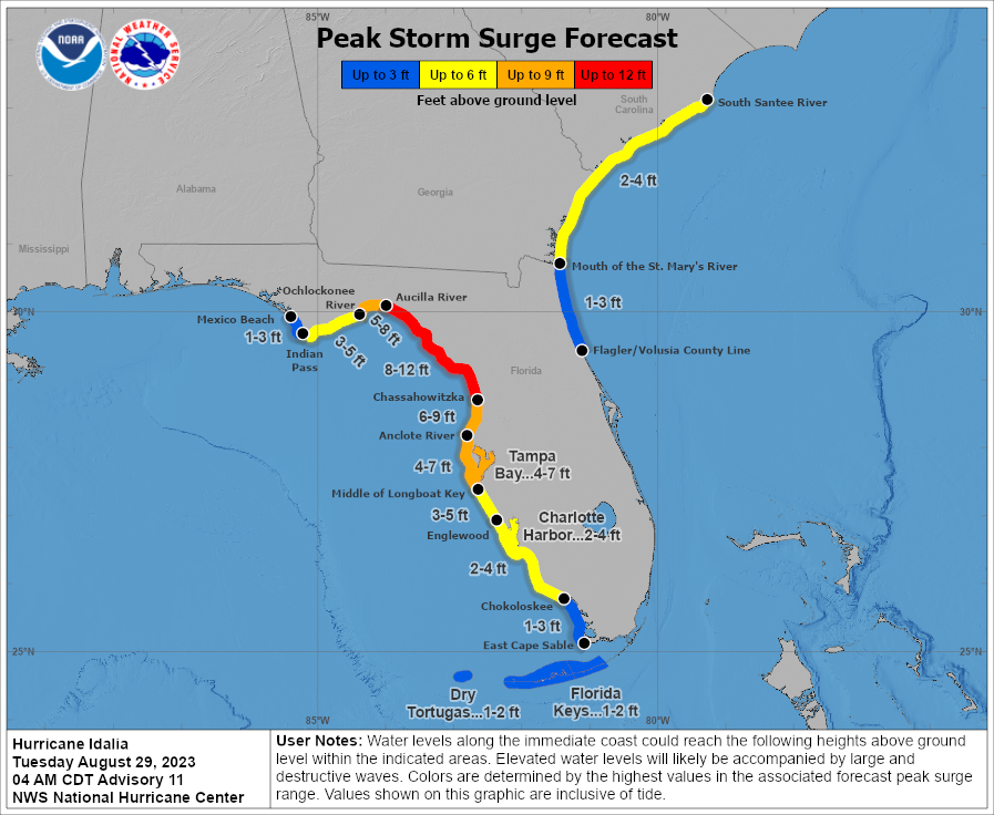
Storm surge height forecasts have now risen, with 8 to 12 foot of surge expected for Aucilla River, FL to Chassahowitzka, FL, 6 to 9 foot for Chassahowitzka, FL to Anclote River, FL, 5 to 8 foot for Ochlockonee River, FL to Aucilla River, FL, and Tampa Bay still expected to face 4 to 7 foot of storm surge.
Storm surge is going to be a significant driver of property damage for the coastal region most affected, with a severe threat to lives and evacuation orders being put in place.
Rainfall totals could be as high as 12 inches around the area hurricane Idalia makes landfall.
The next 24 hours are critical in seeing how intense hurricane Idalia will become, as it feeds off the very warm Gulf of Mexico waters.
As we reported yesterday, Andrew Siffert from BMS noted that any hurricane like Idalia hitting Florida and the surrounding region is expected to be a multi-billion dollar insured loss. Now, the only question remaining is how high the toll will rise.
Track storm or hurricane Idalia and the entire 2023 Atlantic tropical storm and hurricane season on our dedicated page and we’ll update you as new information emerges.


