Hurricane wind speeds forecast across entire Florida Peninsula as Milton approaches
Major hurricane Milton continues to bear down on Florida and in recent updates from the National Hurricane Centre warning areas for the Florida Peninsula have been expanded, with an expectation the storm could sustain hurricane wind speeds all the way as it crosses the state from west to east.
The latest National Hurricane Centre (NHC) update puts major hurricane Milton still at Category 4, with sustained wind speeds of 150 mph and a minimum central pressure of 929 mb.
While hurricane Milton underwent an eyewall replacement cycle as it brushed past Mexico’s Yucatan, this has weakened the storm somewhat but at the same time the wind field has begun its expected expansion.
Now, with 24 hours or so left for Milton to move across very warm Gulf of Mexico waters as it approaches Florida’s west coast, the storm is forecast to maintain its major hurricane status and grow in size, while meteorologist expect this process will drive higher storm surge heights when it reaches landfall.
The forecast models remain converged on an eventual landfall around the Tampa Bay region and sources continue to speak of the potential for $50 billion plus insurance market losses, with some suggesting much higher if a worst case scenario ensues.
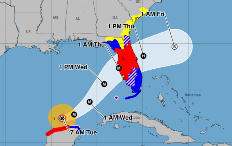
The latest forecast cone and wind speed indications can be seen in the map below from Tomer Burg:
What could that worst case scenario be, most sources suggest a landfall slightly north of Tampa Bay or direct on it, followed by a track along the i4 transport corridor taking hurricane Milton close to cities such as Orlando.
Note in the image above, 100 mph sustained winds are shown for the middle of the Florida Peninsula, in the region of Orlando.
Hurricane Milton is expected to move relatively quickly inland and forecasts are suggesting it could remain a hurricane at the time it nears regions such as Orlando and perhaps beyond to areas of exposure concentration such as Daytona Beach.
With Milton moving towards Florida on a north-easterly trajectory, the landfall location and eventual path across Florida look to be critical to the eventual insurance, reinsurance and perhaps catastrophe bond and insurance-linked securities (ILS) market loss.
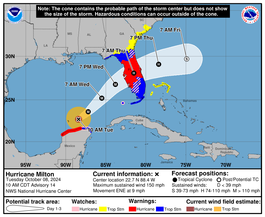
Indicating that impacts are set to spread far inland from hurricane Milton, the NHC’s latest warnings have extended hurricane warnings right across the Florida Peninsula, including across all the locations aforementioned.
You can see the latest warning map from the NHC below:
It’s important to note that a lot can still happen in the just over 24 hours prior to hurricane Milton’s landfall in Florida.
With a trough to the north, Milton’s path could adjust and a landfall to the south of Tampa Bay could reduce the eventual industry loss, although our sources still suggest that would likely be in the region of $20 billion or more, perhaps higher if a high-exposure landfall location is the eventual scenario that ensues.
Slight adjustments to the path Milton takes could have meaningful influence on the quantum of insurance market losses, which is why projections remain in a very wide range at this time.
Thinking about the catastrophe bond market, we understand a number of Florida sponsored names are coming into focus as potentially the more at-risk from hurricane Milton.
At the mid to upper-end of loss projections, cat bonds sponsored by Florida’s Citizens Property Insurance Corporation may also be under some threat.
Lower layer collateralized reinsurance is without doubt exposed to the mid to higher end loss projections being seen, as might be anticipated, while some retrocession arrangements are also undoubtedly exposed to those scenarios.
Reinsurance sidecars focused on property catastrophe risks with US exposure are also likely to see attrition at least, with any loss quantum into the tens of billions of dollars.
But, it must be stated again, there remains uncertainty at this time and the range of loss projections flowing around the market are still from double-digit billions to almost the triple-digit levels.
Hurricane Milton could seemingly come in anywhere between at this time. But, by the time the storm gets much closer to Florida’s Peninsula and we have a better idea of its size and intensity, so the potential for storm surge and damaging winds, as well as their extent, we should also have a better idea of the landfall location and path Milton will take, so projections will become more accurate at that time, likely around the middle of Tuesday.
In its latest update at 10am CDT, 3pm UTC, the NHC said, “Milton is moving toward the east-northeast near 9 mph (15 km/h). A turn toward the northeast with an increase in forward speed is expected to begin later today and continue through Thursday. On the forecast track, the center of Milton will move across the eastern Gulf of Mexico and approach the west-central coast of Florida through Wednesday. The center is likely to make landfall along the west-central coast of Florida on Wednesday night, and move east-northeastward across central Florida through Thursday.
“Maximum sustained winds are near 150 mph (240 km/h) with higher gusts. Milton is a category 4 hurricane on the Saffir-Simpson Hurricane Wind Scale. While fluctuations in intensity are expected, Milton is forecast to remain an extremely dangerous hurricane through landfall in Florida.
“Hurricane-force winds extend outward up to 30 miles (45 km) from the center and tropical-storm-force winds extend outward up to 105 miles (165 km).”
It will be interesting to see how that size of the storm has changed by tomorrow, as that too will give a clearer idea of the eventual impacts.
Finally, storm surge height indications remain significant, with no change as yet and still up to 15 feet projected for some of the most exposed areas of high-value coastline. Again, it will be interesting to see if these heights rise, should hurricane Milton expand significantly in size while sustaining its intensity.
You can track this and every Atlantic hurricane season development using the tracking map and information on our dedicated page.
Also read:
– Mexico’s catastrophe bond presumed safe from hurricane Milton.
– Stone Ridge leads managers cutting mutual cat bond or ILS fund NAVs on hurricane Milton.
– Hurricane Milton could be a huge test for the entire (re)insurance market: Evercore ISI.
– Hurricane Milton losses could amount to tens of billions, but uncertainty high: BMS’ Siffert.
– As hurricane Milton intensifies, Mexico’s catastrophe bond comes into focus.
– Material hurricane Milton losses could change 2025 property reinsurance price trajectory: KBW.
– Cat bond & ILS managers explore options to free cash, as hurricane Milton approaches.
– Hurricane Milton: First Tampa Bay storm surge indications 8 to 12 feet.
– Hurricane Milton is biggest potential ILS market threat since Ian in 2022: Steiger, Icosa.
– Hurricane Milton forecast for costly Florida landfall. Cat bond & ILS market on watch.