Fiona now first major hurricane of season, targets Turks & Caicos

Hurricane Fiona has intensified since battering Puerto Rico and the Dominican Republic and has now become the first major hurricane of the 2022 Atlantic season. The Turks & Caicos Islands are now in its path and facing a damaging blow from the storm.
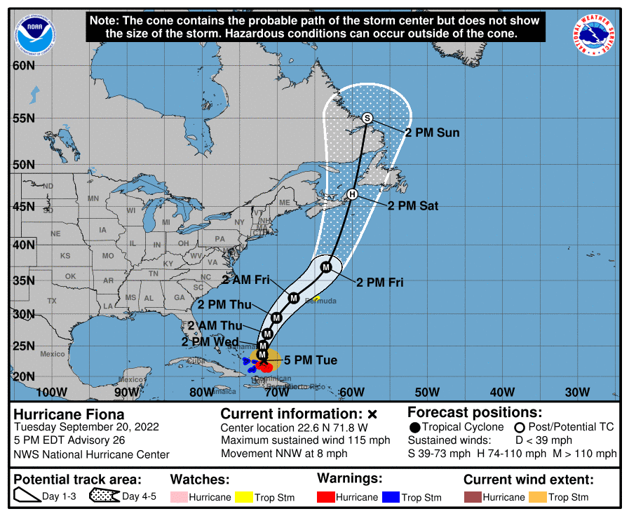
Further ahead, Bermuda is still in the cone of uncertainty with hurricane Fiona expected to maintain its major storm status and grow as it heads north through the Atlantic, so our insurance, reinsurance and ILS market contacts on the island should keep a close watch as the hurricane heads north.
Hurricane Fiona is now a Category 3 strength storm and has sustained winds of 115 mph with gusts to 135 mph or higher.
Grand Turk island is going to take the brunt of Fiona’s impacts it seems, with the eye of the hurricane set to pass very close by this island in the coming hours.
Fiona is still strengthening as well and is anticipated to become a very dangerous Category 4 or stronger storm as it moves north into the Atlantic over the next day or two.
You can see the NHC forecast cone for hurricane Fiona below:
Hurricane Fiona has caused significant impacts to Puerto Rico, with over 30 inches of rain recorded in some parts of the island.
The entire island lost power for a time and Fiona has dealt it a challenging blow at a time when Puerto Rico was still recovering after 2017’s Maria impacts.
The Dominican Republic experienced stronger winds than Puerto Rico, but slightly less rain so far, with 10 inches or more in parts. However, rain bands from hurricane Fiona continue to affect the Dominican Republic and Haiti, so a flood threat is also growing there.
The immediate concern now are the Turks & Caicos Islands, which face strong hurricane force winds, a storm surge of up to 8 feet and potentially 8 inches of rainfall as well.
With Fiona intensifying, a more direct hit from the eye wall could result in significant wind damage occurring, so it is to be hoped the track stays just offshore as forecasts currently suggest.
Beyond the Turks & Caicos, hurricane Fiona will also cause some impacts to the US and British Virgin Islands and Bahamas, with heavy rain and gusty winds expected.
Further ahead, Bermuda remains a target for hurricane Fiona and the warnings issued by the Government there, to prepare for a potential storm impact, should be heeded.
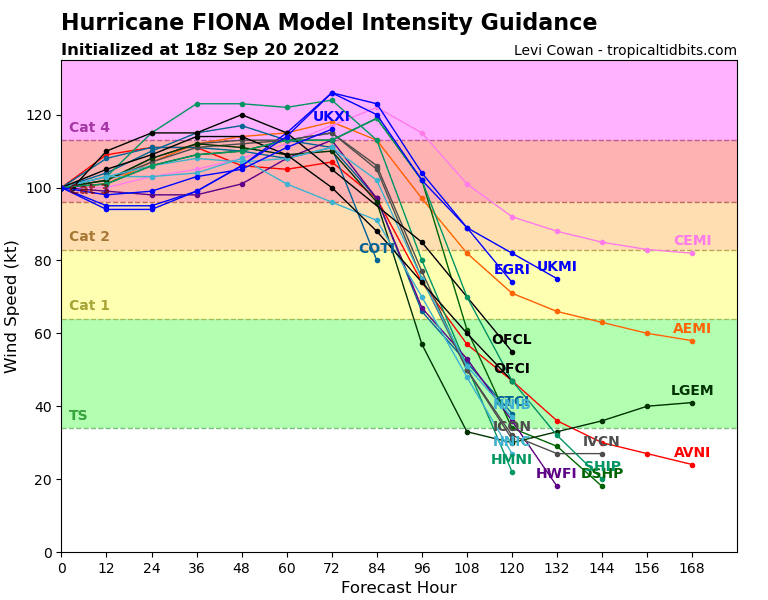
The below intensity model output is from TropicalTidbits.com:

Hurricane Fiona is expected to pass relatively close to Bermuda, just to the west on the current track. This could bring the strongest quadrant of winds very close to the island, so we urge our insurance, reinsurance and ILS market contacts on the island to closely watch the developing path of the hurricane over the next few days, as it would not take much deviation for a closer pass or direct hit to occur.
Bermuda’s Ministry of National Security had warned that “Fiona could have an impact on Bermuda later this week.”
By the time Fiona nears Bermuda it will be an even more powerful hurricane, so we hope the track stays further offshore that forecast and Bermuda is spared any close or more direct impacts.
Further north, the models show hurricane Fiona turning extratropical and then curving west to impact far northeastern Canada as a still large and powerful storm, so interests there should also monitor Fiona’s progress over the next few days.
Track the 2022 Atlantic tropical storm and hurricane season on our dedicated page and we’ll update you as new information emerges.


