Ernesto now third hurricane of 2024 Atlantic season, forecast to pass near Bermuda

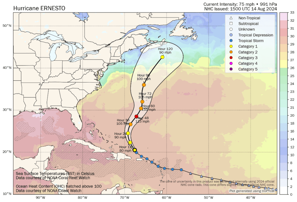
Ernesto has now become the third hurricane of the 2024 Atlantic tropical storm season and is forecast to intensify to major Category 3 status, before weakening slightly and passing close to Bermuda as a Category 2 storm.
Tropical storm Ernesto has been strengthening as it passed to the north of Puerto Rico bringing flooding rains to the island, as well as to some of the Antilles.
Hurricane Ernesto currently has 75 mph sustained winds and higher gusts, while conditions are expected to become increasingly conducive for intensification, with the storm currently forecast to reach major Category 3 strength in around 48 hours time.
Ernesto’s forecast path is expected to be in a general north west direction to begin as it intensifies, after which it is expected to turn north and in around 65 to 70 hours time could pass very close to Bermuda.
As we said in our article on Ernesto on Monday, the storm is being watched closely by interests in the reinsurance and insurance-linked securities (ILS) market mainly for its expected close passage to Bermuda, being the home of a significant proportion of the world’s catastrophe risk capital and a good deal of the industry that supports it.
There remains a lot of uncertainty over how close hurricane Ernesto will be to Bermuda when it nears, with some models suggesting the storm will pass to the west, others to the east and some bringing it very close indeed.
So we continue to urge our friends and partners on the island to keep watching as the Ernesto forecasts develop, as there may be a need to prepare for potential impacts within the next few days.
You can see hurricane Ernesto’s location, forecast path and intensity in the graphic below from Tomer Burg:
Bermuda is of course one of the best prepared locations in the world for storm impacts, with rigorous building codes and a population that is all too aware of the threat of hurricanes throughout the season.
We understand businesses have their contingency planning well underway for Ernesto and we hope all our contacts there remain safe should the hurricane pass close to the island.
Currently most of the hurricane models forecast Ernesto passing Bermuda to the west, at differing distances from the island, but with all suggesting at least strong tropical storm force winds could be experienced.
The GFS model differs, in taking hurricane Ernesto to the east of Bermuda. But, most concerning in its current forecast is the ECMWF model, which takes the storm almost directly over the island in models runs we’ve looked at.
With some days to go the direction hurricane Ernesto takes could shift, taking the storm further away, or closer to Bermuda.
So this really is a system that needs watching closely and those on the island do need to make their preparations sooner than later.
You can track this and every Atlantic hurricane season development using the tracking map and information on our dedicated page.


