Cat bond & ILS fund managers watch invest 95L for potential hurricane development

All eyes will be on the Atlantic tropics over the coming days, as an area of investigation known as Invest 95L is currently forecast by a number of models to have the potential to become a hurricane in the Caribbean and perhaps head towards the Gulf of Mexico.
Already, some catastrophe bond and insurance-linked securities (ILS) fund managers have cited this potential area of concern.
First to do so was Twelve Capital, with the catastrophe bond and reinsurance-linked asset manager saying, “In the Atlantic, there are currently two potential areas of development over the next seven days, one in the Caribbean Sea with a 20% chance, and an area out in the Main Development Region (middle of the Atlantic Ocean), with a 70% chance of development into a storm system. Should either of these areas develop into a Named Storm, the potential strength and direction of these areas will become clearer over the coming days.”
It is the second area mentioned, in the Main Development Region (MDR) of the Atlantic, that is the more significant concern, as this is Invest 95L and some models suggest it could have a run at attaining major hurricane status, with Category 3 wind speeds or higher.
Next to comment was cat bond fund manager Icosa Investments, stating, “Currently, there is such a disturbance designated AL95 on the move. While it’s still early, and forecasts are evolving with each model update, this system could become the first significant storm of the season. Most models agree that AL95 will reach tropical storm status within the next 48 to 72 hours, likely being named “Beryl”. Beyond that, model predictions vary regarding its path and intensity.”
Icosa Investments highlighted that there is a broad spread in the models currently, in terms of the eventual path and intensity of this area of development, ranging from parts of the Caribbean, to Mexico and then if it makes it through that region into the Gulf of Mexico, with anywhere from Texas to Florida a potential destination for the disturbance should it achieve tropical storm or hurricane status and follow that path.
We’ve looked at one helpful model visualisation from Tomer Burg, which shows the spread of ensemble models at approximately one week out from now (seen below).
But Icosa Investments also rightly highlights the potential for this system to intensify, as some models are taking it into the upper categories of hurricane strength and intensity, although uncertainty is significant here.
Icosa Investments explained that, “What’s particularly interesting is that some models suggest environmental conditions are favorable enough for this system to potentially reach Category 4 status. If this happens, it would mark an unusually early major hurricane for the season.
“However, the accuracy of these early model runs is limited, and more time and data are needed for a precise forecast. Also, most models do not anticipate strengthening of this system to that extent.”
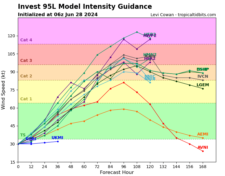
Below you can see Levi Cowan’s model intensity guidance graphic for invest 95L, which shows a number of model runs indicating the potential for strong wind speeds from this storm in future.
We are still five days to a week out from having any greater certainty over this area of development and any potential threats. But, right now, the GFS and ECMWF models both show a tropical system in the Caribbean, with the GFS taking it close to the Antilles, while the ECMWF tracks further south and takes the system into Mexico (other models have a wide range in between).
The HWRF hurricane model deepens what would be tropical storm Beryl and then hurricane Beryl to 940 mb or lower as it tracks through the Caribbean, although that is the most aggressive looking model output we’ve seen so far.
Some models have Invest 95L (potential Beryl) followed closely by another tropical system on a very similar path, both tracking through the Caribbean and with the potential to head towards the Gulf of Mexico.
It’s important to note these model runs are still a long way out and there is little confidence in their outputs at this time.
But, this is the first hurricane threat of the 2024 Atlantic season that has meteorologists watching closely, as well as catastrophe bond and ILS fund managers, no doubt the rest of the reinsurance industry as well.
More will be known on the potential for tropical storm Beryl to form and for any intensification to occur over the next few days.
At this time, the National Hurricane Center gives a 90% chance tropical storm Beryl forms within 7 days, an 80% chance it happens within 2 days from now.
So, to sum up, the second named tropical storm of the Atlantic season looks to have a relatively high probability of forming over the next few days, but significant uncertainty exists over its eventual track and intensity for the time beyond that.
As a result, all eyes will be on the tropics for the next few days and as ever you can track the 2024 Atlantic tropical storm and hurricane season on our dedicated page and we’ll update you as any new information emerges.