What’s Franklin have in store for Atlantic Canada?

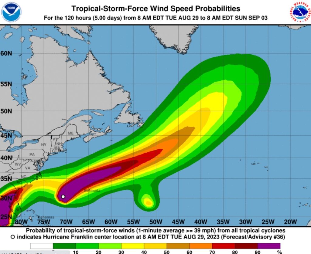
As Hurricane Franklin starts turning North, Atlantic Canada is watching and waiting to see whether it makes a direct hit, or if the storm will weaken before reaching Canada’s coast, as current maps suggest.
Franklin is expected to cross the northwest corner of Bermuda tomorrow, according to the U.S. National Hurricane Center (NHC). It warned of heavy surf rip currents along the U.S. eastern seaboard. And, while the Category 4 hurricane will weaken during the next several days, NHC said it will remain at hurricane strength through late this week.
“While it is still a little premature to mobilize our national Cat response team, our adjuster teams across Atlantic Canada are on high alert and monitoring the situation around the clock,” Michael Connolly, ClaimsPro’s vice president of Atlantic operations told CU.
“Aside from the well-known destruction a hurricane storm will bring, we are also prepared for flooding and wind-related losses that could be caused by a lower-grade storm.”
Maps issued in the early hours of Aug. 29 by Environment Canada and NHC suggest the storm will skirt Canada’s coastline. They show the storm reaching the lower edge of the Atlantic provinces around 3 a.m. on Thursday, Aug. 31.
Winds associated with the storm will arrive several hours sooner – approximately 8 p.m. on Wednesday, Aug. 30 for Nova Scotia and around 8 p.m. on Thursday for Newfoundland. If the storm behaves as currently predicted, Franklin will take its closest swipe at Canada by skirting the edge of Newfoundland later Thursday night and into the morning of Friday, Sept. 1.
Those provinces are already experiencing heavy rainfall from other storm systems, a CBC meteorologist noted, and it’s possible adding Franklin to the mix could exacerbate those conditions.
Meanwhile, NHC data put the likelihood of tropical storm force winds – a one-minute average greater than or equal to 62 kilometres per hour – at between 5% and 10% along the southern edge of Newfoundland, which includes St. John’s.
Environment Canada’s most recent computer models call for Franklin to move along or just inside Canada’s marine forecast district near Category 2 or strong Category 1 intensity late Thursday into Friday.
“Interests in the Southern Grand Banks should pay close attention to forecasts especially now that the storm has reached the upper categories of intensity,” Environment Canada said in a tropical cyclone information statement on the afternoon of Aug. 28. “It will take some time for the intensity to drop down before reaching the edge of the region.
“There is a possibility that some moisture from the hurricane could feed into an elongated low-pressure system well to the north of it over Atlantic Canada beginning later Wednesday.”
Their report also called for large ocean swells to travel far north of the hurricane and bring heavy surf conditions to parts of the Atlantic coast of Nova Scotia and southern Newfoundland starting Wednesday.
Current forecasts call for swells near two metres to approach the shore on Thursday and could break up to three metres, Environment Canada said.
Feature image National Hurricane Center, National Oceanographic and Atmospheric Administration. Page image, Environment Canada.


