Historic Flooding in Yellowstone National Park Washed Out Roads and Bridges
Churning floodwaters in the Gardiner River, along the North Entrance to Yellowstone National Park.Photo: Larry Mayer (AP)
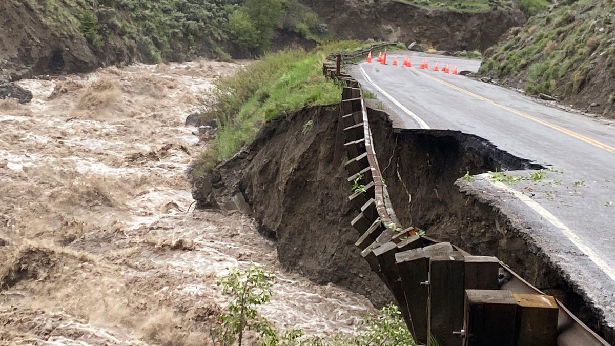
Yellowstone National Park is closed through Wednesday, June 15, and possibly later, as flooding has damaged roads and bridges in northern regions of the park. Floodwaters overtook Yellowstone’s North Entrance Road through Gardner Canyon — among other roads — beginning on Monday. These roadways remain impassable for now. The flooding also caused mudslides and rockslides, making evacuations difficult due to “extremely hazardous conditions.”
The National Park Service is keeping a record of alerts and announcements on its site, and Park County in Montana has released a few detailed statements informing residents and travelers of those locations affected by the flooding.
The AP News reports the floodwaters have impacted communities in the vicinity of Yellowstone National Park, too, including Gardiner, Cooke City, Silver Gate, the Cinnabar Basin, Tom Miner Basin, Mill Creek and Old Yellowstone Trail. These communities and areas are effectively cut off due to the flooding. This has prompted the Montana National Guard to assist the National Park Service and local law enforcement with air lifts and swift water rescues throughout the area.
Record flooding washes out roads in Yellowstone
At least one bridge in the area has been swept away, according to NPR, and many homes have also been destroyed by the floodwaters. As if destroying bridges, homes and stranding people weren’t bad enough, floodwaters have seeped into water mains, making drinking water unsafe. Those stranded in the community of Gardiner, Montana have neither power nor drinking water.
Indeed, the situation in Yellowstone and the vicinity is dire. Meteorologists working with CNN trace the floodwaters to heavy rain and runoff from melting snow, which caused Yellowstone River to overflow. Emphasis mine:
The Yellowstone River, which runs through the park and several Park County cities, swelled to a record high Monday due to recent heavy rainfall and significant runoff from melting snow in higher elevations, according to CNN meteorologist Brandon Miller.
The Yellowstone River gauge at Corwin Springs, Montana, reached 13.88 feet Monday afternoon, surpassing the historical high crest of 11.5 feet from 1918, NOAA river gauge data shows.
The CNN report goes on to call rainfall levels “dramatic,” which could actually be called an understatement in this case: northwestern Wyoming and southern Montana saw more than 400 percent of its average yearly rainfall in June.
That amount of rain together with the snowmelt from, again, record-breaking high temperatures — “record-breaking” has become the frustrating refrain in cases such as these — in the area produced the conditions that triggered the floodwaters and the subsequent hazardous conditions. To keep informed of any updates, follow along with the National Park Service or Park County, Montana.
Photo: Larry Mayer (AP)
Photo: National Park Service
Photo: Larry Mayer (AP)


