Helene may strike Florida as hurricane this week. Wide-range of model intensity forecasts

According to the latest forecasts we should see the eighth named tropical storm of the Atlantic season in the next day and most models are calling for a hurricane Helene landfall into the Gulf Coast, somewhere from Tampa, Florida to Louisiana by Friday, but with a wide spread of intensity and track outcomes, ranging from strong tropical storm to major hurricane, delivering significant uncertainty for the reinsurance and ILS industry.
Right now, we only have an area of weather with an increasingly defined centre and developing circulation to look at, somewhere in the Caribbean near to Mexico.
This disturbance is expected by most meteorologists to become more organised and evolve into a tropical depression today, perhaps being named tropical storm Helene later on as well. The NHC gives a 90% chance of development in 7 days, 70% in 48 hours.
The disturbance, depression or Helene is seen as likely to pass over the Yucatan, between it and Cube, or perhaps over western Cuba, before emerging into the Gulf of Mexico where conditions are expected to be conducive to intensification, perhaps rapid given the very warm SST’s.
Insurance and reinsurance industry meteorologists we follow are saying that there is some uncertainty over how fast this disturbance can become a tropical storm, with dry air entrainment seen as a potential hindrance.
Forecast models have a decent level of agreement currently though, that once in the Gulf this storm will intensify and most take it to hurricane strength, some to major at above Category 3.
Update – Sep 24th, 07:00 UTC:
Helene has yet to be named but the NHC is now releasing warnings and updates and its latest forecast cone suggests a low-end Category 3 hurricane landfall in the Florida Panhandle, but still with a good degree of uncertainty over top-end wind-speed intensity and landfall location.
You can see the latest forecast cone from Tomer Burg’s web resources below:
The remainder of this article still stands today. We’ll update further with a fresh article when greater certainty exists in the forecasts, likely once Helene has emerged into the Gulf, been named and there is more reconnaissance data available to inform the output of models.
The sooner it becomes tropical storm Helene and begins to intensify the greater the chances of a significant Gulf Coast hurricane landfall, meteorologists are saying.
As we said, there is a high-level of uncertainty still, with some models opting for a strong tropical storm Helene, others something potentially more catastrophic in terms of intensity.
There are model runs that show a very deep hurricane, with a low central pressure, intensifying right up to landfall at what would almost certainly be major hurricane Helene.
In terms of track direction and the potential location of landfall for Helene, it ranges from as far down the Florida coastline as Tampa Bay area, right the way around the Panhandle into Louisiana.
As a result, there is an enormous amount of uncertainty still associated with this developing storm or hurricane Helene threat, but enough consensus in the models for the insurance, reinsurance, catastrophe bond and insurance-linked securities (ILS) industry to be on-watch this week as forecast model runs come in over the next few days.
The image below from Tomer Burg’s web resources is a good way of visualising the current model spread for what could become tropical storm or Hurricane Helene:
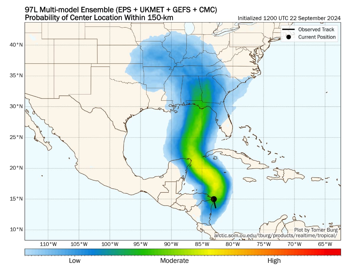
As you can see, the spread is wide but tracks are largely centred on the Florida Panhandle at this time. With high uncertainty and some time to go, with this not even being a named storm yet, things can and will change.
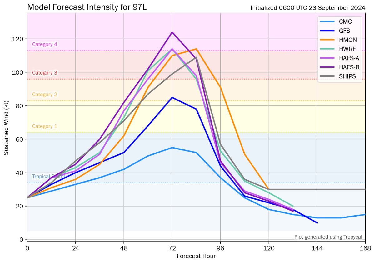
Below, you can see the model intensity guidance from Tomer Burg, which shows most opting for a hurricane Helen in around two to three days, while landfall is expected Thursday or Friday.
As we said above, the faster invest 97L gets organised and develops into tropical storm Helene the stronger the outcome could be.
More time spent organising, dry air entrainment, or land interaction with the Yucatan Peninsula or Cuba could all hinder the storm’s formation and delay its naming, resulting in a weaker landfall scenario.
Faster development and a passage between the Yucatan and Cuba could result in the stronger ends of the model forecasts.
As ever, when there are scenarios showing major hurricane landfalls and some suggesting the eventual track of Helene could be nearer to Tampa, the catastrophe bond market can struggle a bit with liquidity as cat bond investment managers and holders wait and see how the forecast pans out, making the matching of buyers and sellers more challenging.
In reinsurance, a forecast that suggests a relatively high industry loss can result in some last minute retrocession buying, usually in industry loss warranty (ILW) form, but the window of availability and affordability can close quickly.
So uncertainty can breed challenges, in terms of liquidity and hedging and this storm, if and when it becomes Helene, may drive some of those difficulties for the industry.
But, as we all know, even a major hurricane going into a relatively low populated Florida Panhandle location can be a minor industry loss, while something lower intensity tracking straight into a population centre like Tampa can still be very costly.
It’s going to be a week where all eyes are on the forecast models, but we may not have a good idea of how impactful a future storm or hurricane Helene may be for another day or so.
You can track this and every Atlantic hurricane season development using the tracking map and information on our dedicated page.