Hurricane Idalia to hit major Cat 3 strength before winds & surge strike Florida

While still a tropical storm for now, Idalia is forecast to become a hurricane later today, after which there is little to stand in the way of hurricane Idalia intensifying rapidly to near or above major Category 3 strength, before its winds and surge impact the Florida Gulf Coast.
Idalia will be the first hurricane threat to Florida of the 2023 Atlantic hurricane season and as the hours pass the threat looks to be getting more serious, with the NHC now saying it expects the storm will reach major status as it approaches Florida.
Yesterday we reported that tropical storm Idalia was forecast to steadily intensify, move into the Gulf of Mexico and approach the Gulf coast of Florida as hurricane Idalia by Wednesday.
The forecasts for Idalia have continued to develop, in particular on the intensity side, with some hurricane models pointing to a very significant hurricane Idalia making landfall in Florida, while even the NHC warned that hurricane Idalia will be near or at major intensity by the time it makes landfall.
Right now, Idalia is still a tropical storm, but expected to become hurricane Idalia within hours, once it pulls clear of the passage between the Yucatan peninsula and Cuba.
You can see the latest location for Idalia below, using Tomer Burg’s excellent map which shows wind speed forecasts in increments as well, using the NHC data:
The latest NHC update states that there is an increasing chance of dangerous winds and a life-threatening storm surge for portions of Florida, as hurricane Idalia approaches.
Tropical storm Idalia’s current sustained winds are at 65 mph, but that will increase later today and tonight, with Idalia likely to be a hurricane by early Tuesday morning when it is over the southeastern Gulf of Mexico.
The NHC then forecasts, “On the forecast track, Idalia is forecast to increase in forward speed and turn north-northeastward over the eastern Gulf of Mexico on Tuesday and reach the Gulf coast of Florida on Wednesday.
“Idalia is forecast to become a hurricane later today and a dangerous major hurricane over northeastern Gulf of Mexico by early Wednesday.”
The stronger Idalia becomes the greater the chance that intensification continues as well, as the hurricane’s intensity will help it to counter any dry air effects as it travels north.
The NHC now puts hurricane Idalia’s sustained winds at 115 mph before it makes landfall, so at Category 3 major intensity, with gusts of almost 140 mph.
But, the main hurricane models continue to forecast a more intense major hurricane Idalia will near Florida, with sustained winds of as much as 140 mph, putting it into Category 4.
There remains significant uncertainty over the eventual strength of hurricane Idalia, but a stronger storm is all but assured and it seems significant impacts can be anticipated for Florida now, with the insurance, reinsurance, catastrophe bond and insurance-linked securities (ILS) market facing what could be the largest catastrophe loss event of the year.
As we said yesterday, the reinsurance and ILS market has shifted its attachment points higher up the risk tower in recent years, which suggests that primary insurers would retain a larger proportion of even a strong Category 1 hurricane landfall in Florida, than they would just a few years back.
But, as we also said in yesterday’s report on Idalia, “Should hurricane Idalia strengthen further over the warm Gulf of Mexico waters then the chances of a larger reinsurance market loss, with greater ramifications for the ILS and perhaps catastrophe bond market, increase in line with the more intense impacts and more significant property damage that would be expected.”
If hurricane Idalia makes major status then wind damage could be much more significant than the Category 1 storm that was forecast yesterday.
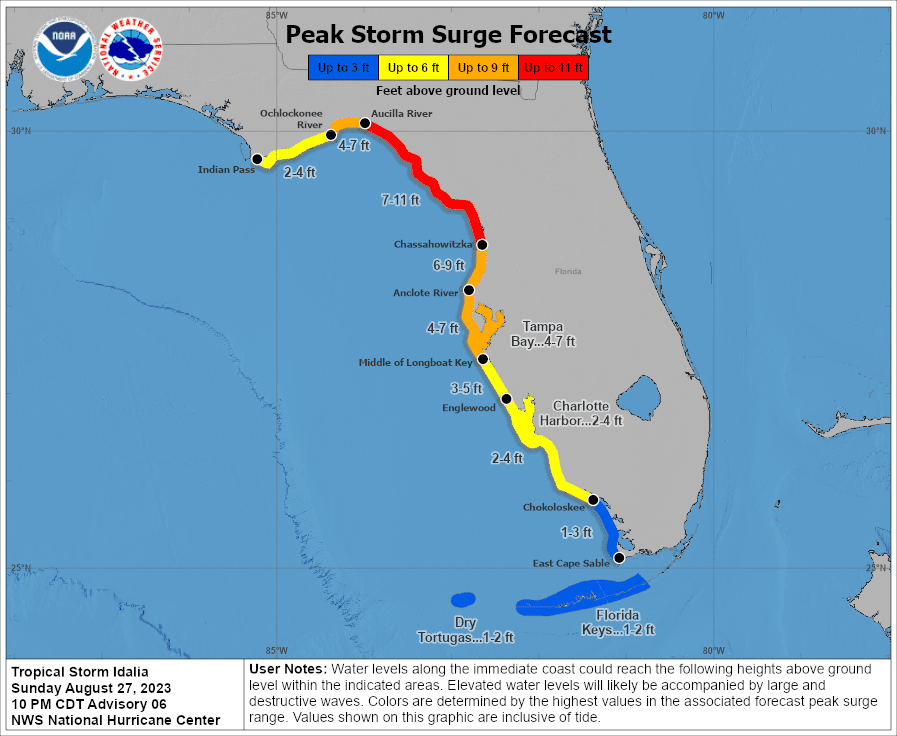
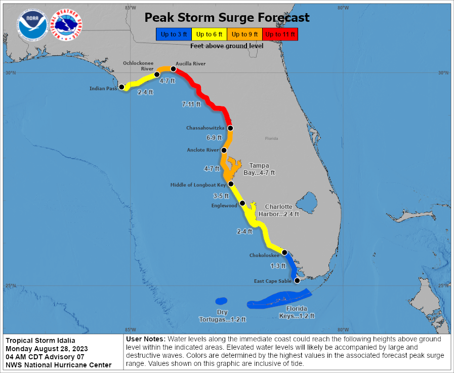
 At the same time, the storm surge forecast suggests widespread coastal flooding impacts for Florida, with peak surge amounts of between 7 feet and 11 feet now forecast.
Given the Gulf of Mexico shelf shallows in towards the shore in the Panhandle region of Florida, a major hurricane could push significant surge inland here, with ramifications for increased property damage and greater economic and insurance market losses.
NOAA warns, “Idalia is now forecast to become a major hurricane before it reaches the Gulf coast of Florida. The risk continues to increase for life-threatening storm surge and dangerous hurricane-force winds along portions of the west coast of Florida and the Florida Panhandle beginning as early as late Tuesday.”
The eventual landfall location of hurricane Idalia is another key factor in determining the impact and losses for insurance, reinsurance and ILS interests.
There are parts of the Florida Panhandle and Big Ben that have much lower insured value concentration, while at the same time, Tampa Bay now in the NHC’s forecast cone for hurricane Idalia where the opposite would be true.
As a result, no matter how strong hurricane Idalia becomes, the direction of travel is the critical factor in determining whether this is a really significant loss for the insurance, reinsurance and perhaps ILS markets, or a more manageable one.
There is, of course, also a chance hurricane Idalia can’t intensify quite as much as some models suggest, if its brush with Cuba hinders intensification or if dry air manages to slow development. But, as each hour passes and updates come through, the chances of this are increasingly being seen as lessening, with most now suggesting that major hurricane Idalia will approach Florida as at least a Category 3 storm by early Wednesday.
Track storm or hurricane Idalia and the entire 2023 Atlantic tropical storm and hurricane season on our dedicated page and we’ll update you as new information emerges.


